
Agriculture in County Durham
The history of agriculture in the county strongly reflects the contrast between west and east, between the high moorlands and foothills of the Pennines on the one hand and the lowlands of the rivers Wear and Tees together with the East Durham Plateau on the other. The former, with its greater altitude, higher rainfall and a growing season one to two months shorter than in the lowlands, has the inferior soils. In fact, according to the Ministry of Agriculture, Fisheries and Food’s five-fold division of land quality, the thin soils derived from the Millstone Grit and Calcareous Sandstone in the dales and those of the peaty moorlands are classified as the two lowest grades, 4 and 5 respectively. The bulk of the medium to heavy soils in the eastern half of the county, largely derived from glacial drift, are grade 3, with smaller areas of grade 2 confined to the middle Tees west of Darlington and to ones near Durham and Chester-le-Street. (There is no grade 1 land in the county.) This physical background has given rise to a persistent contrast between pastoral activities in the west and arable or mixed farming in the east.
Agricultural systems and related settlement patterns in the county were largely established by the 12th century. In the east were regularly-spaced, small nucleated villages, surrounded by open fields, where the strips and furlongs of scattered holdings were worked communally. Each village or township consisted of ‘townfields’ ofarable, with meadow and pasture intermixed and, beyond, town meadows, pastures and commons. The former was measured in bovates or oxgangs, i.e. the area which one ox could plough and make ready for sowing in one season. Such a unit varied from place to place according to type of soil, but averaged 12 to 15 acres. There was much bondage land, with tied cultivators. Boldon, after which township Bishop Le Puiset’s land survey of 1 183 is named, provides an example of labour services demanded. Twelve cottagers were registered, from whom work was due two days a week, while 22 villagers owed three days a week, together with carting services and extra labour at times of ploughing, harrowing and harvest, plus dues of oats, hens and eggs.
The dales provided fingers of sheltered lowlands extending into the Pennine moorlands for a few clustered hamlets and isolated farmsteads. Here evolved small enclosed fields held in severalty, not communally. A variant of the infield-outfield system operated, the proportion of arable townfield of each township being very small compared with extensive areas of unenclosed and unimproved waste beyond. Pastoralism prevai led, and the land was predominantly exchequer land providing rent for the bishop, although services might be required in the bishop’s hunting preserve. In Teesdale, which did not constitute part of the bishop’s estate, colonisation was aided by monks from Rievaulx, who were given privileges in the 12th century by Bernard de Baliol (William II had granted much of Teesdale to the Baliols in 1093) for pasture and timber rights, with permanent dwellings provided for lay brothers in assarts (clearings). Here, as in Weardale, the demand for charcoal for local smelting contributed to the wasting of woodland.


The general contrast in land use between east and west at this early date is indicated by the pattern of arable land, calculated from the returns from the surveys of their lands by Bishop Le Puiset and Hatfield. Both clearly show higher densities confined to the east. While both surveys cover only lands belonging to the Lord Bishop, the fewer blanks on the later census of Hatfield reflect its more comprehensive nature. The largest proportion of the area left blank on the two maps constituted land belonging to the prior and monastery of Durham, although a few barons also controlled large estates – Brus of Hartlepool, the Baliols and, by the 14th century, most notably the Nevilles of Raby, Brancepeth and Teesdale.
From the western dales there was a steady upward encroachment – with, in Weardale, the bishop’s licence – to complete the medieval penetration of the Pennine moorlands. As early as the 13th century effective use was being made of some of the high fells over 2,000 ft. by the seasonal transfer of animals. Circular sheep folds dating from this time are still visible, but evidence suggests that this form of transhumance was less strongly developed than in Westmorland and Northumberland. A related but more extensively developed and flexible system of common pasturing of animals on fell land evolved. It was known as stinting, and became an important component of moorland farming over several centuries. The carrying capacity of stinted pasture was worked out by trial and error through time, with quality of fell or pasture grass, type of animal and demand combining to determine the average price of stint. Both price and allocation of stints per landowner were calculated annually, at which time stint users had to declare the number and type of livestock that would graze the land. Conversion rates might mean, for instance, that ten stints could support 10 mature cattle, five horses or 25 sheep. Overstinting was prohibited and punishable, with an impounder employed to oversee and seize surplus animals.
Agriculture in late medieval lowland Durham suffered not only from periodic plagues, but also from incursions across the Scottish border. The latter brought devastation to standing crops, especially in the 14th century, while on occasions animals were driven south across the Tees to the safety of the Cleveland Hills. Corn yields were generally low as a result of the slow exhaustion of heavy soils from years of grain growing on the open fields. The ultimate break with this feudal world has been attributed to an external stimulus – London’s demand for coal. Certainly it was the emergence of activity connected with the mining and transport of coal which boosted the rise of a capitalistic economy in the North-East. Concomitant political events in the turbulent years from the mid-16th to mid-17th centuries – dissolution of the monasteries, Rising of the North, Civil War, Commonwealth, and the Jacobite Rebellion – saw large estates confiscated by the Crown in many parishes. The consequent changes in land ownership saw the entry of new, mercantile families. An important factor for an economic working of the land was the introduction of short-term leases at a realistic rent. Previously there had been the widespread custom of ‘tenant right’ whereby tenants had copyholds of inheritance at nominal rent in return for border services in the event of Scottish invasion. Land engrossment (amalgamation) and enclosure were crucial organisational adjustments among farm holdings.

The enclosure of common fields and pasture to form compact farmsteads began in the mid-16th century, but was especially a feature late in the following century, well ahead of enclosure in the English Midlands. The process was confined to the east of the county. Although some two-fifths of enclosures in the two centuries up to 1 750 concerned the enclosure of common pasture, they were characteristically much smaller than the majority, which enclosed large town-fields, formerly divided into strips and in permanent cultivation. All enclosures were accomplished by agreement among the interested parties, although half were confirmed by chancery decree – usually in the court of the bishop of Durham – often to legalise the division made. Robert Hodgson has calculated that at least 75,000 acres (12 per cent of the total area of the county) were enclosed between 1550 and 1750. Even then, this figure may well be an underestimate since some enclosures almost certainly escaped documentation, while others were recorded in bishop’s acres, larger units than the standard acre.
Enclosure permitted the turning of land exhausted with cropping into pasture land in order to supply the increased demand for wool and for meat and dairy products. There was a demand also for extra hay to support the growing number of horses who served the spreading network Teesdale of coal wagon-ways. The new emphasis on pastoralism led to the dwindling or disappearance of some fifty villages, particularly in the south-eastern quarter of the county. At the same time there arose cattle fairs in Durham, Darlington, Barnard Castle, Sedgefield and, just across the boundary, in Newcastle and Yarm. Dairy produce was stimulated in the vicinity of the largest centres, notably Newcastle. Butter was being exported through Newcastle and Stockton by the end of the 17th century.
The era of change also produced its own agricultural ‘improvers’. Most prominent was George Culley, born at Denton in 1734, who earned a national reputation. He and his brother Matthew, who both visited Robert Bakewell, learnt the trade on their father’s farm, but had to go to Fenton in Northumberland to acquire an appropriate holding. A variety of innovations followed. The efforts of another two brothers, whose farming careers were spent entirely within the county, Charles and Robert Colling, are remembered above all for the breeding of the Durham shorthorn. It was a beast noted for its sturdiness and yield of beef and milk; its sheer size meant that much fat was available for soap and candle making. The initial increase in the size of cattle in the mid-18th century is said to have come from a few Friesians imported to the Sedgefield area. Charles (at Ketton, just north of Darlington) and Robert (at Barmpton, nearby) subsequently proceeded by selective breeding to produce prodigiously heavy animals. The ‘Durham Ox’ of Charles and the ‘White Heifer’ of Robert were both taken on tour around England at the beginning of the 19th century as wonders of the age. The transport of the heavy beasts – the ‘Durham Ox’ weighed 270 stone – in special carts was no mean feat. They were immortalised in contemporary engravings and prints, and also in the naming of hostelries.
A second phase of enclosure in the county began in the mid-18th century. It complemented the irony of the earlier phase on the lowland eastern half of the county, when enclosing of arable townfields gave a boost to pastoralism. Now, upland fell enclosure somewhat surprisingly brought about an increase in cereal production. Grain prices had risen throughout the 18th century from the demand of an increasing industrial population; during the Napoleonic Wars the cost of importing grain rose dramatically. As a result, the upland areas were viewed for their potential contribution to this market. On the more suitable commons of the foothill zone, the newly-enclosed land was rented and leased for up to ten times its former value and put under the plough. Relict patterns of ridge and furrow, such as those above Wolsingham and St John’s Chapel, however, are lasting evidence that barley and oats were widely grown at altitudes of 1-1,200 ft. Part-time farming, undertaken for subsistence or standby among an increasing number of leadminers, contributed to what today appears as either optimistic or foolhardy cultivation.
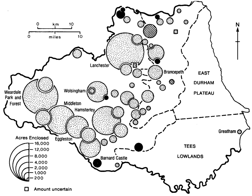
The process of enclosure from the mid-18th century contrasts markedly with the earlier period not only in its western distribution and husbandry. It was achieved not by individual agreement but through Parliamentary acts and awards, many of which covered very extensive areas. Enclosure of Lanchester Common and Weardale Park both involved more than 15,000 acres; Wolsingham was more than 10,000; several others exceeded 2,000 acres. Altogether over 110,000 acres, or some 17 per cent of the county, were enclosed in the period 1750-18″70, all but a mere 5,000 involving common, moor, fell or waste. It is from this time that the landscape of the western half of the county received its distinctive mantle of stone-walling, aligned in a regular grid-pattern up hill and across fell.
The provision of a mosaic of compact, more manageable holdings was not accompanied by a commensurate advance in husbandry techniques which the new organisational framework might have suggested. In his Tour of 1 769 Arthur Young had summarised Durham agriculture, apart from a few large, well-managed units, as simple and primitive. Bailey drew the same distinction in his General Account of Agriculture in 1810. Innovation was confined to the educated managers of a few large farms; the majority, particularly those on short-lease holdings, still persisted with the traditional and monotonous rotation of two crops and bare fallow. There was no proper appreciation of preserving soil fertility, to the extent that most arable ground often received only lime, apart from lying fallow, while at the same time manure might be stacked on pasture land. In short, there was no beneficial integration of crop and livestock. The Crop Returns of 1801, with the dominance of traditional grains and restricted coverage of turnips and potatoes, are a statistical confirmation of Bailey’s observations. The livestock itself was provided with mad-equate accommodation on most farms. Lack of capital was a handicap to small farmers, whose lives, according to Bailey, was onerous to the extent that he deemed them ‘greater slaves than their servants’.
Bell, in his mid-century review of the county’s agriculture, repeated some of the same points, by which time a further handicap to efficient agriculture was evident. According to Bell there was not a parish in the county that was not scarred from mining – of lead in the west and coal elsewhere. Over large areas colliery owners either bought or farmed land, in order to avoid meeting claims for surface damage and compensation for loss of crops from tenant farmers. Where paid, compensation often provided a return twice the rental or commercial value of the land – hardly an incentive for dedicated farming. However, the rapid spread of mining in the second half of the 19th century did provide an incentive for hay and oats production in order to support the growing number of pit ponies. The colliery districts also provided a market for pigs, which were fattened in the backyards of miners’ cottages before ritual slaughter and a shared distribution of cuts among neighbouring families. The miners themselves also provided their own form of market gardening on the edge of pit villages. Their allotments, notable for the distinctive architecture of sheds and pigeon lofts, also became the basis for fruit and vegetable competitions, not least in the growing of leeks. Durham County Agricultural Society, founded in 1786, encouraged competition on a wider basis.
The second half of the century saw a decline in wheat acreage, which was more than offset by a rise in pasture and meadow for increased cattle numbers. Earlier there had been the decline in and cessation of cultivation of two specialised crops. Mustard had been grown only for a relatively short period following the country’s first manufacture of the condiment in Durham City in the late 17th century. Flax, on the other hand, had a long history of cultivation, and was the basis of linen manufacture in several towns. For a brief period towards the end of the late 18th century, the concentration of mills in Darlington along the Skerne was the largest of any town in England. Symptomatic of its position was the patent for a water-driven flax spinner applied for by John Kendrew of Darlington in 1787. The yarn was dispatched to weavers in Durham, Cumberland and Yorkshire. In the first part of the 19th century, however, the greater textile resources of West Yorkshire were exploited, while Darlington entrepreneurs, with Quaker influence prominent, turned to other manufactures.
The present century has seen an increasing application of science to farming, the most obvious summary index of its success being reflected in the reduction of workers engaged in agriculture. At the beginning of the 19th century the eighteen thousand employed full-time in agriculture formed by far the leading occupation group; a hundred years later the figure had declined by a quarter. Today under 6,000 – 1.2 per cent of the total – earn their living from the land. Cereal cultivation, with its progressive mechanisation, had spearheaded this trend. Horse-drawn reaping machinery was introduced in the 1870s and binders in the 1890s. The mechanisation of threshing began earlier, in 1875, when the first mill was powered by a harnessed horse walking a circular path to drive a thresher in an adjacent barn. Circular wheelsheds which housed these former ‘horse-gins’ remain a distinctive feature of many lowland farms. Steam power was widely applied by mid-century; mobile threshers, drawn by traction engines, came into use before the end of the century.
The present century has also seen two new land uses in the west of the
Gin-gang, Beamish county – forest plantations and reservoirs. The former, predominantly of spruce and larch, are the work of the Forestry Commission from 1919. Hamsterley Forest in Weardale is the most extensive plantation. In contrast, Teesdale, apart from Egglestone parish, has withstood the Commission’s advances. The explanation lies in land ownership and the policy of the Raby and Strathmore estates, which have continued to foster pastoral activities in the dale and maintain higher moorland for sheep and grouse. A dozen reservoirs have been built to trap the headwaters of western valleys. By far the biggest are the two most recent constructions – Derwent (1967), on a tributary of the Tyne, and Cow Green (1970) on the Tees. Around the margin of the former, more land has been taken for picnic areas and a yachting centre. The damming of the Tees just above Cauldron Snout was achieved after a public inquiry. Controversy raged, not because the area was valuable agriculturally but unique botanically, being part of the Teesdale assemblage on Widdybank Fell of alpine and arctic flora, survivors of the last Ice Age.
A recent aspect of land use competition is the intertwining of agriculture and mining for a second time on the exposed part of the coalfield. In some instances it is only a few years since the land has been physically restored from colliery workings and reclaimed for agriculture. A second wave, this time of open-cast workings, requires whole areas to be taken out of production and the land stripped to expose the seams beneath. History is also repeating itself in that farmers may well be anxious to accept the compensation offered rather than continue to work what may be marginal land in the present context of national – and international – quotas and restrictions.
Despite the increasing scientific application to all aspects of production, and despite changes in scale and context, the basic physical endowment of the county has ensured that the contrast between east and west is as strong as at the time of the first colonisation when, according to an early monk of Durham, the county was released from being ‘nothing but a hiding place for wild and woodland beasts’. A pastoral west and a mixed arable and stock-rearing east are the basis for the simple arrangement of land use: two-fifths of the county which is in tillage and temporary grass is predominantly in the east; the one-fifth in rough grazing is entirely in the west; the two fifths in permanent grass is shared.