
A History of Lincolnshire
I Setting
The land of Lincolnshire lies trapped between the great rivers of Trent and Humber on the north west and north, the sea on the east and the Wash with its major rivers the Ouse and the Nene to the south; only in the south west is the county open to the rest of England. And this fact means that, despite the variations within the area which have left their mark on its political history, social structure and farming practices so that even today a ‘woldsman’ is seen to be a person apart from a ‘fensman’, there is an essential unity to the region which found expression from early times.
With some 72 miles/115.8km from north to south and at its widest 55 miles from east to west, it is the second largest of all the English counties. It is nearly as far from the Humber to Stamford as from Stamford to London, nearly as far from the coast to the Trent as from the Trent to Cheshire. And within this large area there is a wide range of scenery and – geographical features. There are hills and valleys, steep inland cliffs and undulating plateaux, wet fens and dry scrubby heathlands, limestone moors and sandy warrens, chalk plains and heavy clay basins, light gravelly barns and thick silts – hard rocks fit for building and soft soils ideal for farming.
Most people are convinced that Lincolnshire is flat. Even drivers along the Great North Road over the rolling heathands of west Kesteven between Stamford and Newark still assume that Lincolnshire and the Fens are different terms for the same area, while the hundreds of people who holiday every year on the Lincolnshire coast firmly hold this opinion despite the fact that the main routes to Skegness and Mablethorpe cross the limestone uplands and pass over the southern Wolds.
One reason for the prevalence of this view may be that some of the different regions within the county merge into one another. There are some sharply defined features: the steep face of the Lincoln Cliff, the western edge of the northern Wolds and the even more abrupt former sea-cliffs on the southern Wolds. But elsewhere one passes without noticing from one region to another – from the limestone into the Witham Vale east of Lincoln for instance.
Boundaries
This is particularly true of the southern and western boundaries of the county. Along the south the river Welland provides part of the frontier, but a more or less artificial line across the Fens defines the rest. In the south west, there is no clear dividing line between Lincolnshire and its neighbours; the county boundary divides almost identical villages, placing some in Lincolnshire and others in Rutland, Leicestershire or (further north) Nottinghamshire. North of Grantham the line joins the river Witham briefly before cutting across to the Trent.
Here at last is a major natural barrier. But the county boundary does not stay for long with the river. Just before it flows into the Humber, the Trent passes through a large flood plain, and part of this clay basin now lies in Lincolnshire. The Isle of Axholme, as it is called, together with the Yorkshire part of the Humberhead Marshes, Hatfield Chase, has its own characteristic countryside and its own settlement pattern.
The boundaries of Lincolnshire on the south and west are probably late in creation, relying for their delineation more on agreement between neighbouring communities over the use of tracts of common land or upon the boundaries of different estates than on natural features. But elsewhere there are natural frontiers. The Humber in the north provides a real barrier only partly lessened today by the new Humber bridge; the crossing of this treacherous water by ferry in earlier days was very hazardous.
To the east lies the coast. The shore line has fluctuated greatly over the ages. At one time it lay further to the east, bordered by chalk cliffs. Flooding, caused by the tilting of the land, the rise in sea level and climatic variations, at one time brought the coastline in successive waves further west until it reached to the eastern margin of the Wolds and up the Witham, Welland and Trent valleys. Today, along much of its length there are wide and once inhospitable marshes broken by a number of small rivers. On the central section for about 18 miles/30km from Mabletborpe to Skegness, large dunes have been washed away in great floods as the former protecting shoals off-shore finally disappeared below sea level. The eroded material has been moved southwards into the Wash, that vast (and formerly more extensive) basin into which the Witham, Welland, Nene and Ouse all poured their waters like a huge sedimentation tank. The coastal marshes and fens of Lincolnshire despite periodic flooding have provided both a rich living for its inhabitants and a series of landing sites and havens for sea-goers.
These fluctuations and their consequent modifications of landscape and vegetation have constantly altered the face of the region. And Lincolnshire is still changing today, with both short-term man-made alterations and longer-term natural changes. It is a living land where men and the forces of nature meet face to face.
Regions
The most notable features of the map of Lincolnshire are the two areas of uplands, the limestone heathlands in the west and the chalk wolds in the east, with the vale between them. These mark off the major geographical and settlement regions of the county.

Of the lowlands, the largest is the Fens in the south east. Lincolnshire contains about one third of the great fenland region of England; the rest lies in Norfolk and Cambridgeshire. This is a complex area, divided between the silt fens and the peat fens. Although they have much in common with each other, the other lowland zones are all distinctive. The Marsh to the east of the Wolds, some 40 miles/64.3km long and five to ten miles/8-16km wide, runs northwards into Yorkshire; it is drained by short stubby streams which flow off the Wolds into the sea, and defended from saltwater invasion by sea walls which often form the platforms for sharply winding roads. The wet clay Lincoln Vale between the Wolds and the heath, full of low hills sometimes with caps of sand or gravel, proved in earlier times to be a barrier to movement from the limestone uplands to the chalk uplands and the, coast; its main line of communication was north-south. The Trent valley to the west of the limestone, with its loam and gravels, was fertile: river silt, boulder clay and patches of well-drained soils led to heavy settlement and intensive farming. Not so the small Isle of Axholme, some 10 by 15 miles/16-24km in extent. Here early forests and later peat and large areas of freshwater flooding created by the congruence of three major river systems produced one of the most intractable landscapes in England; cut off from the rest of Lincolnshire by the Trent and from the rest of Yorkshire and Nottinghamshire by deep marshes, Axholme for long preserved an independent identity.
The uplands though relatively slight are distinctive. The Lincolnshire Wolds are part of a chalk belt stretching from Yorkshire into Norfolk, broken by the Humber and the rivers of the Wash. These rolling hills and downs, 45 miles/72.5km long and rising to about 500 feet/152.5m (Normanby le Wold), have their own particular scenery and settlement patterns; with deep valleys (especially in the southern half) and woodlands, they harbour some of the richest farms and estates in the county. The general north-south thrust of this ridge is confirmed by the early main roads along the length of the Wolds, but there is a marked difference between the north and south Wolds, divided roughly by a line from Market Rasen to Louth.
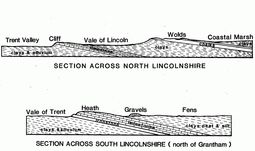
The other upland region is the limestone ridge. The tail end of that belt which sweeps across England in a curve from the Cotswolds through , Oxfordshire, Northamptonshire, Leicestershire and Lincolnshire to the Humber. In Lincolnshire the region is divided into two. The Kesteven uplands south of the Lincoln Gap were noted for their rich soils and ‘better air’, but the Cliff to the north of Lincoln was poorer. The belt narrows as it goes northwards; about 20 miles/32km wide when it enters the county, it only averages five to six miles/8-9.6km just south of Lincoln, and from Lincoln to the Humber only two to three miles/3.2-4.8km. It rises to 200-300 feet/60-91m in parts of Kesteven where it is deeply cut by river basins. Along the western edge of this ridge are beds of ironstone, the reason for the later growth of the steel towns of Corby (Northants) and Scunthorpe; one of these beds forms a lesser ridge most clearly seen along the scarp between Lincoln and Grantham. On the eastern side of the heathland is a line of low clay hills capped and surrounded by gravels and watered by springs. The earliest and densest settlement in the county was along the edges of these uplands and in the valleys of the south, while the main routes through the region ran along the more barren top.
Routes and Rivers
The limestone ridge provided the county with its main overland link with the rest of England. But the water routes probably counted for more in Lincolnshire’s story. The small but important havens on the coast like Tetney, Saltfleet and Wainfleet gave access to the rest of eastern England and to the continent, while the mouths of the Humber-Trent and Wash, although dangerous, were the main points of entry. In the south the Nene and the Ouse drew upon a vast hinterland and built up foreign links, and the smaller rivers, the Welland, its tributaries the East and West Glen (sometimes known as the Eden and the Glen) and the Wash fall off the limestone and drain across the southernmost parts of the county.
The land between the Wolds and the limestone uplands is drained in part by the Witham, a large river which flows south east from Lincoln to Boston and the Wash, assisted by the Slea flowing from the limestone (the Ancaster Gap) on the west and by the Bain flowing from the chalk and sandstones of the southern Wolds on the east. The more northerly part of this vale contains the Ancholme which runs northwards into the Humber. To the west of the limestone the Trent flows northwards and empties into the Humber, bringing the life of the southern Pennines and the Midland plain into and through this region. The southerly part of the Trent-Belvoir valley carries the northward-flowing upper Witham and Brant rivers which, once they have joined, turn eastwards through the Lincoln Gap. The main thrust of the river system, like the upland areas, is from south to north.

The making of Lincolnshire
Once the basic material of the landscape had been laid down by successive waves of sedimentation, layer upon layer of soft and hard rocks, two main forces helped to make Lincolnshire look as it does today. First the land has tilted eastward and on several occasions sunk below sea-level. The erosion which followed created the scarp face which the limestone ridge presents to the west and the more gradual slope eastwards. The same pattern is true of the chalk Wolds deposited by the sea on top of a belt of sandstone, part of which can be seen in the Spilsby area. In places (as at West Keal) the sea has cut the east face of the chalk into cliffs.
The second major force was glaciation. The first Ice Age affected the whole county, smoothing the uplands and deepening the clay vale and fenland basin. In particular, it changed the course of the rivers. Originally, these followed the slope of the land eastwards from the lower Trent basin through the Ancaster Gap, the Lincoln Gap and the Humber Gap to the North Sea. But as the ice melted, the Trent turned northwards to flow into the Humber, and the upper Witham and Glen valleys developed as ice-edge meltwater channels. The various tributaries to the west of the limestone were gathered up by the Trent or the Witham so that today the Ancaster Gap is almost dry, an important area for naturalists as well as for historians. Only the Welland and the Gwash escaped this re-orientation, but their tributaries flow southwards for long distances before turning east.
The melting glaciers filled the valleys and covered the marshlands and much of the southern limestone with a patchy veneer of boulder clay on which heavy forests grew. Ridges and small islands of sand. and gravel were left along the edges of the uplands and on the top of hills of clay. In the last glaciation, the ice only reached as far as the southern Wolds; a huge lake was created in the fenland basin, central Lincolnshire and lower Trent vale into which were deposited further extensive spreads of sand and gravel which were exposed when the ice melted. It was this pattern of river and soil which more than anything else affected where man lived and what he did in Lincolnshire, and the exposure of the different rocks and soils provided the region with its chalk, ironstone and limestone quarries and its sand and marl pits.