
Urban and Railway Development in the 19th Century
We have seen how, in the rural parts of Kent, the population increased until the middle of the 19th century and then often began gradually to decline. In the towns, on the other hand, and in the villages which grew into towns, the increase of population continued throughout the century and indeed has continued to the present day, except in the old-established Wealden market towns such as Cranbrook and Tenterden, where the population has remained more or less stationary (in number) for the last hundred years.
Apart from the general growth of population, the main causes of urban development in 19th-century Kent were: the industrialisation of Thames-side, of the lower Medway Valley and to a less extent of Swaleside; the construction of the railways, and consequently the close linking of West Kent with London; and the emergence of the seaside holiday custom.
Towards the end of the 18th century Canterbury was still the largest town in the county, with a population of over 9,000, followed by Rochester and Maidstone, each with about 8,000 inhabitants, and Dover with rather more than 7,000. By 1801 Chatham had outstripped Canterbury, the census figure being 10,500 which no doubt included many sailors’ and soldiers’ families living in the town, busy at that time with naval and military preparations for the French war. For much of the 19th century Chatham remained the most populous town in the county, although later it was surpassed by its neighbour, Gillingham.
By 1800 Margate and Ramsgate had established themselves as seaside resorts, followed by Broadstairs, Deal, Dover and Folkestone. Sea-bathing and the drinking of sea water, as an alternative to visiting the well-known spas, began to come into fashion soon after the year 1750. The Royal Sea Bathing Hospital at Margate was founded in 1791, by which time the town’s reputation as a seaside resort had already been established for 30 or 40 years. The visitors usually came from London by boat. Charles Lamb, in an essay written in the 1820s, remembered with affection ‘the most agreeable holyday of my life’ which be spent at Margate in 1790 and the journey thither from London in ‘the old Margate hoy’. The first steam-boats, of about 70-80 tons, began to run about 1815, and when they got over their teething troubles made the trip more quickly and with considerably more certainty than the sailing ships which might take anything from 8 to 40 hours. Nevertheless, even by steam it was a lengthy journey, and the latter part of it in open water with no protection from the Essex coast. Some few passengers were bold enough to risk the discomfort of rounding the North Foreland and made for Ramsgate (as salubrious as Margate and rather more select), but most of the Ramsgate visitors came overland from Margate. Throughout the 19th century the two resorts were in rivalry, with Ramsgate (including St Lawrence) leading in population except for the first 20 years or so, as these figures show:
| 1801 | 1821 | 1841 | 1861 | 1881 | 1901 | 1921 | |
| Margate | 4,800 | 7,800 | 11,000 | 10,000 | 18,200 | 26,700 | 46,500 |
| Ramsgate | 4,200 | 7,600 | 13,500 | 15,100 | 23,100 | 28,400 | 37,200 |
(The census in 1841 and again in 1921, was taken in June at the beginning of the holiday season, and the figures for those years must have included a fair number of visitors.) Some of the most attractive urban architecture in Thanet, e.g. Cecil and Hawley Squares at Margate, and Wellington Crescent, the Paragon, and Royal Crescent at Ramsgate, belongs to the period when the two towns were developing into thriving and fashionable resorts. From the harbours of both towns, Ramsgate’s dating from the 18th and Margate’s from the early 19th century, packet-boats plied regularly across the Channel to Boulogne and Ostend.
Broadstairs enjoyed something of the reflected glory of its two larger neighbours. For those who preferred a more genteel, quieter holiday, with everything on a miniature scale, Broadstairs possessed great attraction and it grew steadily from being a somewhat scattered township of less than 1,600 souls in 1801 into a flourishing resort with a population of over 7,000 in 1901; and during the last 150 years, like its expar9ive neighbours, it has continued to grow.
Herne Bay, on the northern coast of the county, developed at much the same rate as Broadstairs. Deal was already a town of some size by 1800 and did a lively trade, lawful or otherwise, with the many ships that anchored in The Downs to avoid bad weather or to await a favourable wind. After steam had ousted sail The Downs were less used as a safe anchorage, and the resultant decline in Deal’s commerce was scarcely balanced by its development as a resort. Indeed, the population figure for 1841, when the census was taken in the holiday month of June, was actually a little below the figures for 1811, 1821 and 1831, when the count was made in May. From 1800 to 1900 Deal just about doubled its population, a much slower rate of growth than that of the Thanet towns.
Dover was primarily a port for passage to and from the Continent, and a garrison town; it was only secondarily a seaside resort and probably it owed its development as such to the large number of visitors, mainly military with their ladies, who frequented the town at the time of the French war. In the 1830s and 1840s it was a fashionable rather than a popular resort, and Marine Parade and Waterloo Terrace stand (or did, until some years ago) as reminders of 19th-century Dover as a watering-place of ton.
Like Dover, Folkestone, as a seaside resort, dates from the time of the French war when soldiers were encamped in the neighbourhood, and the town, along with its neighbours, Sandgate and Hythe, flourished as it had never done before.
However, when the war came to an end Folkestone made little headway. Its population, which numbered 4,200 in 1811, rose to 4,500 in 1821, fell to 4,300 in 1831, rose to 4,400 in 1841—and by 1851 was 7,550. Thereafter the town prospered, its population reaching more than 30,000 by the end of the century. This comparative newness of Folkestone is strikingly illustrated in its buildings; outside the old town, down in the ravine towards the harbour, it is almost impossible to find a building of anything but Victorian, or later, architecture.
Folkestone’s sudden boom was due to the building of the South Eastern Railway from London, which was begun in 1842 and reached the coast in 1843. It was not the first railway to be constructed in Kent. The earliest, which was also the first railway to be constructed anywhere in the world to convey passengers by locomotive, was the six-mile line from Canterbury to Whitstable, opened on 3 May 1830. Although Canterbury was still the premier town in the county, the more far-sighted citizens saw that it was bound to be outstripped by other towns with better means of transport, and a scheme was mooted for making the Stour navigable as far up as Canterbury. An Act of Parliament was obtained in 1825 authorising the scheme, but it was found to be too costly and, as an alternative, a harbour was constructed at Whitstable and linked with Canterbury by a railway line. The land between the two towns rises to a height of 200 ft. and the railway involved a tunnel half a mile in length and banks with gradients of 1 in 40 and, in one place, 1 in 28. Stationary engines were installed to pull the trains up the steeper slopes. The locomotive, the Invicta, proved less powerful than had been hoped and its use had to be confined to a level stretch of the line hardly more than a mile in length. In fact, the Invicta so disappointed the Railway Company that they offered her for sale in 1839, but no purchaser could be found. Now she stands by the Dane John garden in Canterbury and probably few people who see her realise that she was the first locomotive ever to haul (although only just) a passenger train. The line continued in use for a century, and with the packet boat that sailed every other day from Whitstable for London formed for some years the speediest and easiest route between Canterbury and the capital.
The Canterbury and Whitstable Railway is not to be compared in importance with the South Eastern Railway, running through Tonbridge and Ashford to Folkestone and Dover. In the early days of railways. Parliament was determined to see that the country was not unnecessarily ‘cut up’ with lines, and there was to be only one outlet from London to the south and the south-east. The South Eastern were therefore compelled to run over, first, part of the London and Greenwich Railway, next over the Croydon Railway, and then over the Brighton Railway before striking off eastwards at Redhil on to its own line. One advantage of the route which it followed through the Weald was that the line could be laid out almost dead straight for the whole 46 miles from Redhill to Ashford, and there were few gradients to be negotiated. The disadvantage of this route was that it ran through the less populous parts of the county and missed the developing towns in the north, and in the Medway Valley. When in 1845-6 the South Eastern Company put forward projects for new lines to serve the centre and north of the county they hinted”that they had been obliged to adopt the Tonbridge-Ashford line because of opposition of landowners and towns (especially Maidstone) elsewhere. No doubt there was some truth in the allegation, but it did not weigh sufficiently with Parliament to enable the South Eastern to get the additional powers that they were seeking.
A primary reason for carrying the South Eastern line to the coast was to attract the cross-Channel traffic. The continuation of the line from Folkestone to Dover, which involved building the 100-ft. high Foord viaduct at Folkestone, and four tunnels and a sea-wall along the coast, as well as blowing up part of the cliff, was a major engineering feat. The opening of the line in 1844 made it possible to complete the journey from the French or Belgian coast to London comfortably within a day.
Maidstone’s first line, opened in 1844, ran along the Medway from Paddock Wood (then known as Maidstone Road). It soon took away the traffic from the Maidstone coaches, although the distance to London by rail through Paddock Wood, Tonbridge and Redhill was 56 miles, as against 35 miles by road.
The next year a branch line was constructed from Tonbridge to Tunbridge Wells, which had been known as a fashionable spa since the 17th century. As with every other town in West Kent, a railway link with London immediately led to rapid expansion; the population of the parish of Tonbridge which, in the 19th century, included also Tunbridge Wells, went up from 12,500 in 1841 to 21,000 in 1861 and 29,800 in 1871.
There was an equally striking growth in the size of Ashford immediately after the railway works were built there. In 1841 Ashford and Willesborough together had 3,700 inhabitants. In 1851, two years after the works had opened, the number was 62000 and 10 years later, 7,700.
In 1846 the South Eastern built a line from the main line at Ashford, following the Stour Valley to Canterbury and a year later extended it to Ramsgate and Margate, with a branch from Minster to Sandwich and Deal. Thus the Thanet resorts obtained a railway link with London, but by a long and circuitous route, and the railway did not bring about a development at Margate and Ramsgate comparable with that at Folkestone.
In the northern part of the county the first line to be built was the London and Greenwich Railway, opened in 1836, which was constructed throughout its whole length of three and three quarter miles on a viaduct of brick arches. Another line in North Kent was laid a few years later, from Gravesend to Strood, alongside the canal; in the tunnel it was, apparently, laid on the canal towpath. Opened in 1845, it was purchased during the following year by the South Eastern Company who filled up the canal through the tunnel, and laid a double track. Its westward extension, the North Kent Railway from Gravesend via Dartford and Charlton to join the London-Greenwich line, was constructed in 1849. Seven years later a railway was built following the west bank of the Medway, from Strood to Maidstone, connecting there with the line to Paddock Wood.
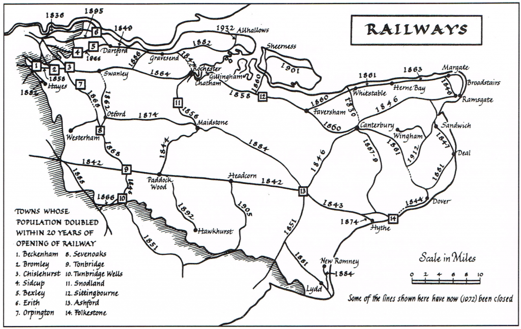
Up to the middle of the century the South Eastern had virtually a monopoly of railway transport in Kent. In 1853 a new company, the East Kent Railway, obtained powers to construct a line from Strood via Chatham, Sittingbourne, and Faversham to Canterbury. When it was opened from Strood to Faversham in 1858, and to Canterbury in 1860, it seemed a harmless little local line unable to compete with the South Eastern system. However, a period of sharp rivalry opened up when the East Kent Company (and their subsidiary) were granted wider powers, and extended their line both eastward and westward—from Canterbury to Dover (1861); from Faversham to Whitstable (1860); Herne Bay (1861), and Margate and Ramsgate (1863); and from Rochester across the Medway via Sutton-at-Hone (now Swanley Junction) to St Mary Cray (1861), whence the East Kent (afterwards more suitably known as the London, Chatham and Dover) had running rights over the lines of other companies to London. With these extensions the ‘East Kent’ ceased to be an unimportant local line and competed directly with the South Eastern for the continental traffic at Dover, for the Thanet traffic, and for the traffic from the Medway towns. With railway transport available, Sittingbourne developed as an industrial town (its population increased by 60 per cent. in the 20 years following the opening of the railway); and a branch line was constructed to Sheerness and Queenborough, over the ill-fated Kingsferry Bridge, in 1860.
After this, the main railway development, as the map above shows, was in West Kent, which shared in London’s rapid expansion. Everywhere the opening of a new line was followed by a marked increase in population:
| Railway | |||||||||
| opened | Population | ||||||||
| Beckenham | 1858 | 1851 | 1,700 | 1871 | 6,100 | 1881 | 13,000 | 1901 | 26,300 |
| Bromley | 1858 | 1851 | 4,100 | 1871 | 10,700 | 1881 | 15,200 | 1901 | 27,400 |
| Chislehurst | 1865 | 1861 | 2,300 | 1871 | 3,300 | 1881 | 5,300 | 1901 | 7,400 |
| Orpington | 1865 | 1861 | 1,700 | 1871 | 2,400 | 1881 | 3,100 | 1901 | 4,300 |
| Sevenoaks | 1868 | 1861 | 4,700 | 1871 | 5,900 | 1881 | 8,000 | 1901 | 9,700 |
| Bexley | 1866 | 1861 | 4,900 | 1871 | 6,400 | 1881 | 8,800 | 1901 | 12,900 |
| Sidcup | 1866 | 1861 | 300 | 1871 | 400 | 1881 | 1,900 | 1901 | 52800 |
The development of these towns occurred, in the main, because the railway made it possible for thousands of men and women to work in London and share in its growing prosperity, whilst living in Kent. Along Thames-side, from Gravesend westward to the London border at Woolwich, the expansion was partly due to the railway link with London, and partly to industrial development. No place exemplifies the extent and character of the change on Thames-side more vividly than Erith. In 1841 its population was 2,082, and that included 221 harvest labourers, the census having been taken on 7 June; 10 years later it was scarcely larger; in 1861, however, it was 4,100, in 1871 8,300 and by 1901 over 25,000. Crayford doubled, and Dartford trebled, in size between 1861 and the end of the century. A similar development overtook the villages between Dartford and Gravesend, as these figures show:
| Stone | Swanscombe | Northfleet | |
| 1861 | 1,000 | 2,300 | 5,700 |
| 1881 | 2,500 | 4,500 | 8,800 |
| 1901 | 5,100 | 8,800 | 12,900 |
In the last thirty years of the century the railways and industrial development shifted Kent’s centre of gravity, economically and in terms of population, from the east and south to the north and west. So long as Kent was primarily an agricultural county, the poorer lands in the north-west did not count for much; as industry grew and the county became increasingly under the influence of London, so the formerly undeveloped north-west took on a new importance. Penge, Beckenham, Bromley, Orpington, Chislehurst, Sidcup, Bexley, Erith, Crayford and Dartford, in area a twentieth of the whole county, now contain over one-third of the total population; a century ago the population of the same area represented scarcely more than a twentieth of that of the whole county.
The shift in the centre of gravity is reflected in the Parliamentary representation. Before the Reform Act of 1832 not a single borough west of the Medway returned a member to Parliament; today (if the Rochester and Maidstone constituencies are omitted as belonging to mid-Kent) West Kent returns eight members against six from East Kent. The representation of Kent in Parliament before 1832 reflected in a rough and ready way the balance of importance as it had existed in the Middle Ages. The county itself was represented by two Knights of the Shire; Canterbury, Rochester, Maidstone and Queenborough each returned two members, and so did the Kentish Cinque Ports, Dover, Hythe, Sandwich and New Romney. In all, therefore, Kent sent 18 members to Parliament.
In some of the boroughs the elections were comparatively democratic even before the Reform Act. At Canterbury, for example, there were 1,000 voters and no one exerted an undue influence on them. Maidstone had 600 voters and, although earlier in the 18th century the town’s two seats were regarded as being at the disposal of the earl of Aylesford, his influence had declined. Rochester had the same number of voters, namely, 600, but one of the two seats there was customarily filled on the nomination of the Board of Admiralty, or of Ordnance, that is, the Government of the day. The Government always managed to secure the election of its nominees at Queenborough where the number of voters was 131, of whom 56 were employees of the Admiralty or the Ordnance. There were many Government employees also at Dover, but as the total number of electors for the borough was 1,200, the Government could not often command more than one of the two seats. Sandwich with 480 voters, was much under the influence of the Government and so was Hythe. The number of electors at Hythe was 126, all of them freemen of the borough, but only 22 of them resident in the town. The other 104 were scattered all over the country, and probably most of them never visited the town except to cast their votes. The situation at Romney was even more scandalous for there were only eight electors, all tenants of Sir Edward Dering, and all voting for the candidates of their landlord’s choice. It was the most flagrant example of a ‘nomination borough’ in the county.
The Reform Act of 1832 did not alter the number of members of Parliament for the county as a whole, but some seats were redistributed. Queenborough and New Romney ceased to be represented and Hythe’s representation was reduced to one. Sandwich kept its two members, but the constituency was enlarged to include Deal and Walmer. Chatham was given one seat, and Greenwich (then part of Kent) was given two. Finally the number of County members was doubled, East Kent and West Kent each returning two. The distribution of Parliamentary seats was thus brought more nearly into line with the distribution of population and wealth in the county. However, the rapid growth of some towns during the 19th and early 20th centuries as a result of industrial development and proximity to London has made necessary several subsequent redistributions of seats since the great Reform Act of 1832.